Tuesday, April 16, 2024
50.0°F

‘High, wide and handsome’ A historical and scenic take on the Missouri Breaks

by CAROL MARINO
Daily Inter Lake | November 22, 2020 12:00 AM

If you sketch a few long, wavy lines across a blank page, thread a river and stretches of fence line through the middle and brush a broad watercolor of sky across the top, you’d have something loosely resembling how Missouri Breaks country looks from the road.

With wide-open spaces whipped by the whims of the wind, this arc of landscape on the Rocky Mountain Front is my kind of country.

My husband and I recently took a history trip of sorts to Fort Benton and the Upper Missouri River Breaks National Monument. Many years ago, on a fun, family rafting trip with our kids, my siblings and their spouses, we’d taken out at Fort Benton and spent time in town combing through the museums and old fort, the only original post still in Montana. I was eager to return.

Before we got to Fort Benton the last week in October, we passed through familiar grounds along Montana 89: Dupuyer — where I once spent the night in the same B&B as bestselling Montana author and White Sulphur Springs native Ivan Doig often stayed, while I was on a five-day CASA bicycling fundraising trip from Glacier Park to Yellowstone; Bynum — stopping in again at the Trex Agate Shop that's been around for more than 80 years and whose original owner, Marion Brandvold, found the first baby maiasaura bones in 1977 and showed them to famed paleontologist Jack Horner whose team went on to discover nearby Egg Mountain; and Freezout Lake near Choteau — where, on previous occasions as amateur birders we’d either ridden our bikes or driven through 6-inch deep snow, and where on this visit we ate sandwiches while glassing the remaining fall migrating birds — a huge flock of snow geese in flight, tundra swans, Canada geese and rafts of ducks.

The Upper Missouri River Breaks country features sweeping contours, bluffs and valleys surrounding the river and vast native shortgrass prairies with endless vistas of Big Sky Country, widely scattered farms and few folks.

In the heart of this country sits Fort Benton, known as the “Birthplace of Montana,” “Chicago of the Plains” and “World’s Most Innermost Port.” In 1878 — its heyday — 10,000 pounds of freight, 2,000 passengers and 30,000 buffalo hides found their way to Fort Benton’s levee. The town was the Northwest Territories’ hub of commerce, with steamboats — some over 250 feet long — plying the Missouri to and from St. Louis loaded with goods destined for the Northwest, Canada and Europe, along with wagon trains crossing the Northwest loaded with buffalo robes and hides, beaver furs and timber.

Fort Benton was where Charles C. Conrad, who would become the founder of Kalispell, made his fortune as a shipping magnate after leaving his family’s plantation in Virginia in 1868 after the Civil War.

During the Montana Gold Rush (1862-1869) gold seekers paid up to $200 to travel by steamboat from St. Louis to Fort Benton, the last navigable stop on the “Old Misery.”

In its boomtown days, all roads led to Fort Benton, from the stage lines connecting Helena and Virginia City, to those leading from Lewistown and Judith Basin. Fort Benton was a high society city on par with Paris.

While in town, we stayed at the Grand Union Hotel. Listed on the National Register of Historic Places and one of Montana’s most famous landmarks, the hotel was built in 1882 at the height of Fort Benton’s prosperity and is the oldest operating hotel in Montana. In its day, it was considered to have the finest accommodations between St. Louis and Seattle. After nearly a century and a half of changing ownership, deterioration and varied management, the grande dame was fully restored in 1999 to its former elegance and is a destination in and of itself, situated on the banks of the Upper Missouri River Wild and Scenic River.

Our room, one of 26 in the hotel’s three stories, overlooked the river and Fort Benton Bridge. All guest rooms have private baths and are furnished with authentic pieces of the era. A portrait of Nez Perce Chief Joseph hung on one wall in our room.

The Fort Benton Bridge, an 825-foot-long bridge adjacent to the hotel, was the first steel bridge to span the Missouri. After the railroad replaced steamboat traffic in 1877, Fort Benton had begun to decline. Construction of the bridge in 1888 connected the town to the rapidly growing Judith Basin and gave ranchers and farmers a means for transporting their livestock and grain, re-establishing Fort Benton as an important commerce hub. Now a walking bridge, vehicles were able to utilize it until 1962.

THE FORT Benton museums had already closed for the season, but Sean Williams, park ranger for the Upper Missouri River Breaks National Monument who answered the phone at the Missouri River Breaks Interpretive Center operated by the Bureau of Land Management, not only offered to open the museum by appointment, but gave us a personal tour before leaving us to explore it on our own.

While we were looking around he called us over to the floor-to-ceiling picture windows overlooking the river where he’d just spotted a coyote wandering along the far river bank and we took turns watching him through binoculars.

While there, a gentleman also staying at the Grand Union happened in (not realizing the museum would have been closed). Lucky for him and us, because Ian, from the Bahamas, had driven out to the Virgelle Ferry the day before and recommended we do the same — after we assured him we had four-wheel drive. We armed ourselves with snacks and a map from the center and headed toward Loma on a day promising 73 degrees and a 35 mile-per-hour Missouri Breaks breeze.

The drive into the backcountry was glorious. There were just a few spots of the gumbo Eastern Montana is famous for — the kind of mud that plugs your wheel wells and warrants signs stating the road is impassable during and after heavy rain. The route took us deep into farmland where road signs are few and far between and only the tiny, infrequent “Virgelle Ferry” signs with a pointing arrow gave us hope we were on the right track.

A woman named Bev has been operating the ferry, established in 1913, since the 1990s, as her parents had back to the 1960s. We chatted under sunny skies and Chinook winds as the ferry carried us across the Missouri and while her young charges romped on the deck.

Before we drove away, Bev mentioned an antique store just up the road, saying it may look like it's closed, but it isn’t. The Virgelle Mercantile is a destination stop. I bought a small, solid wood table. The handwritten receipt said I’d bought a parlor table.

RETURNING TO Fort Benton via a different route (glad we’d bought the map), we stopped at Decision Point near Loma — the confluence of the Marias and Missouri rivers where in 1805 the Lewis and Clark Expedition holed up for five days to scout both rivers to determine which was truly the Missouri that would take them to the Pacific. Overlooking the same place where Lewis and Clark once stood brought the area’s rich history home.

The following day we left Fort Benton for home but not before a couple of side trips. First, we pulled off Montana 87 and drove 6 winding miles down to Carter Ferry, another ferry still operating that late in the season. We’d been told by Bev at Virgelle that the ferries, which are operated by Chouteau County as a road service, typically run from around Easter to Thanksgiving, depending on the ice.

Our last stop was a detour to the Benton Lake National Wildlife Refuge. The refuge wetlands are dominated by native shortgrass prairie, surrounded on three sides by the Highwood, Big Belt and Rocky Mountain ranges. As late in the season as it was, there wasn’t much in the way of waterfowl, but the views were, as Choteau author A.B. Guthrie wrote, “high, wide and handsome.”

Despite abundant sunshine, the air now held a distinct chill that last day in October. It was time to head home ahead of winter, soon to come.

Community Editor Carol Marino may be reached at 758-4440 or community@dailyinterlake.com.

photo

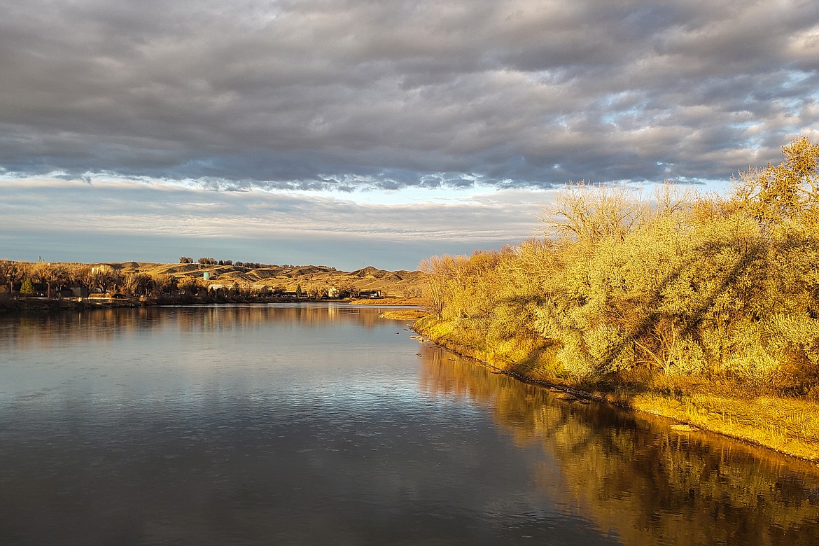
Looking downriver from the Fort Benton Bridge over the Missouri

photo

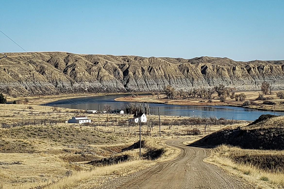
Carter Ferry is another operating ferry on the Upper Missouri about 47 miles upriver from Virgelle Ferry.

photo

Established in 1913, the Virgelle Ferry is one of three ferries still running seasonally on the Upper Missouri River and is operated by Chouteau County as a road service. There is no charge to have your car ferried across the river.

photo

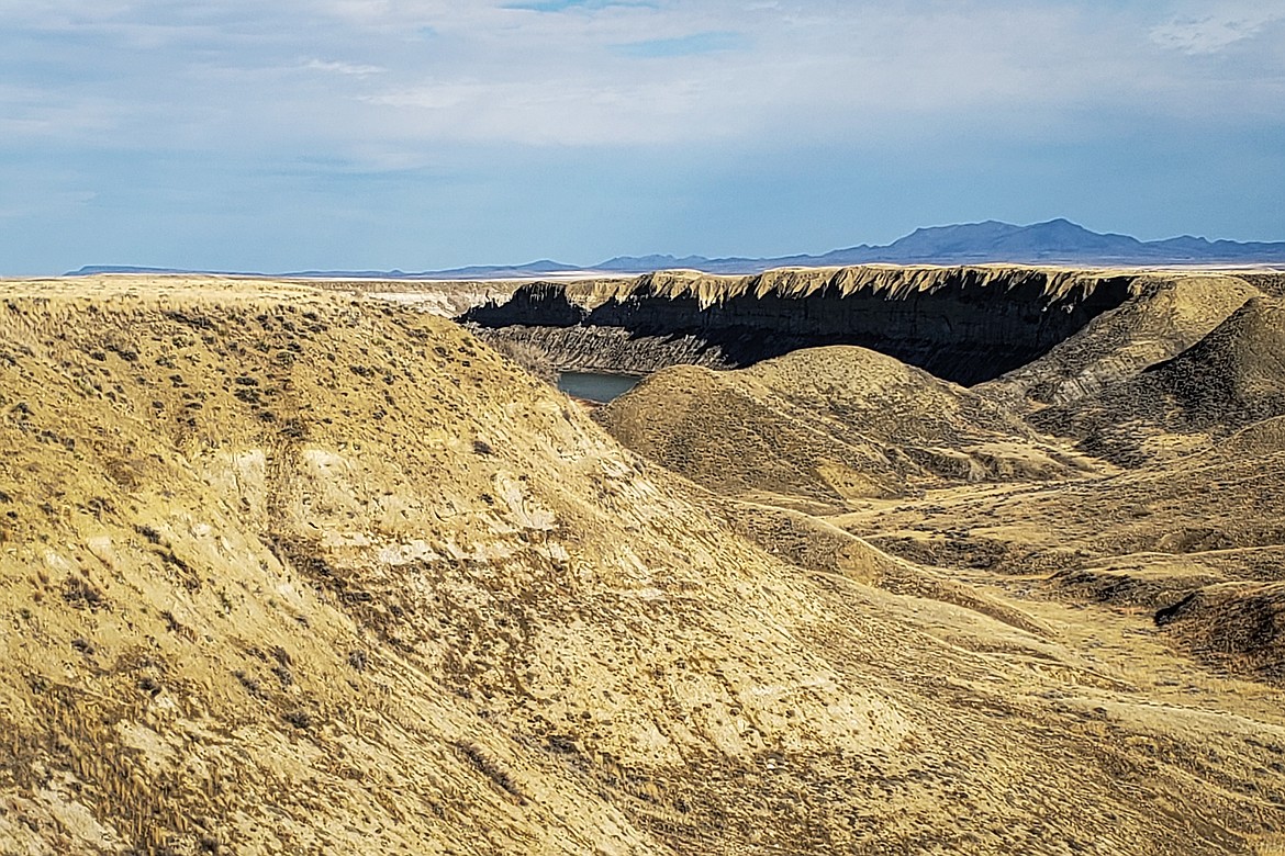
Wide open spaces and big sky define the Missouri River Breaks landscape.

photo

Built in 1882, the Grand Union Hotel in Fort Benton sits right on the banks of the Missouri River and is the oldest operating hotel in Montana. In Fort Benton’s heyday during the steamboat era, the hotel was considered the finest accommodations between St. Louis and Seattle. The 138-year hotel has been restored to its original elegance and offers 26 modern guest rooms. — photo provided by Grand Union Hotel

photo

Climbing back up on the Upper Missouri Breaks National Monument bench after crossing the Missouri River on the Virgelle Ferry, one of three operating ferries on the river. The Bears Paw Mountain Range is visible off to the northeast and is where Nez Perce Chief Joseph surrendered to the U.S. Army in 1877. The rifle he used as a symbolic gesture is on display at the Missouri Breaks Interpretive Center in Fort Benton.

photo

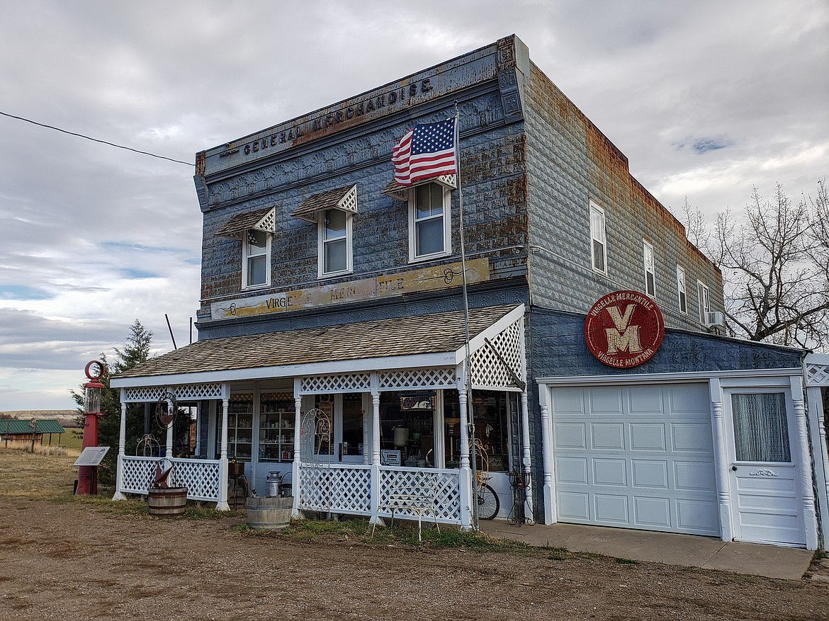
An online search of the Virgelle Mercantile says the mercantile was built in 1912, the same year the town of Virgelle was founded by Virgil and Ella Blankenbaker, and was a shipping point for area homesteaders. Besides two antique shops, the mercantile has rooms on its second floor and fully restored, genuine guest cabins available for overnight guests.