Weather, lack of resources exacerbate NW Montana fires
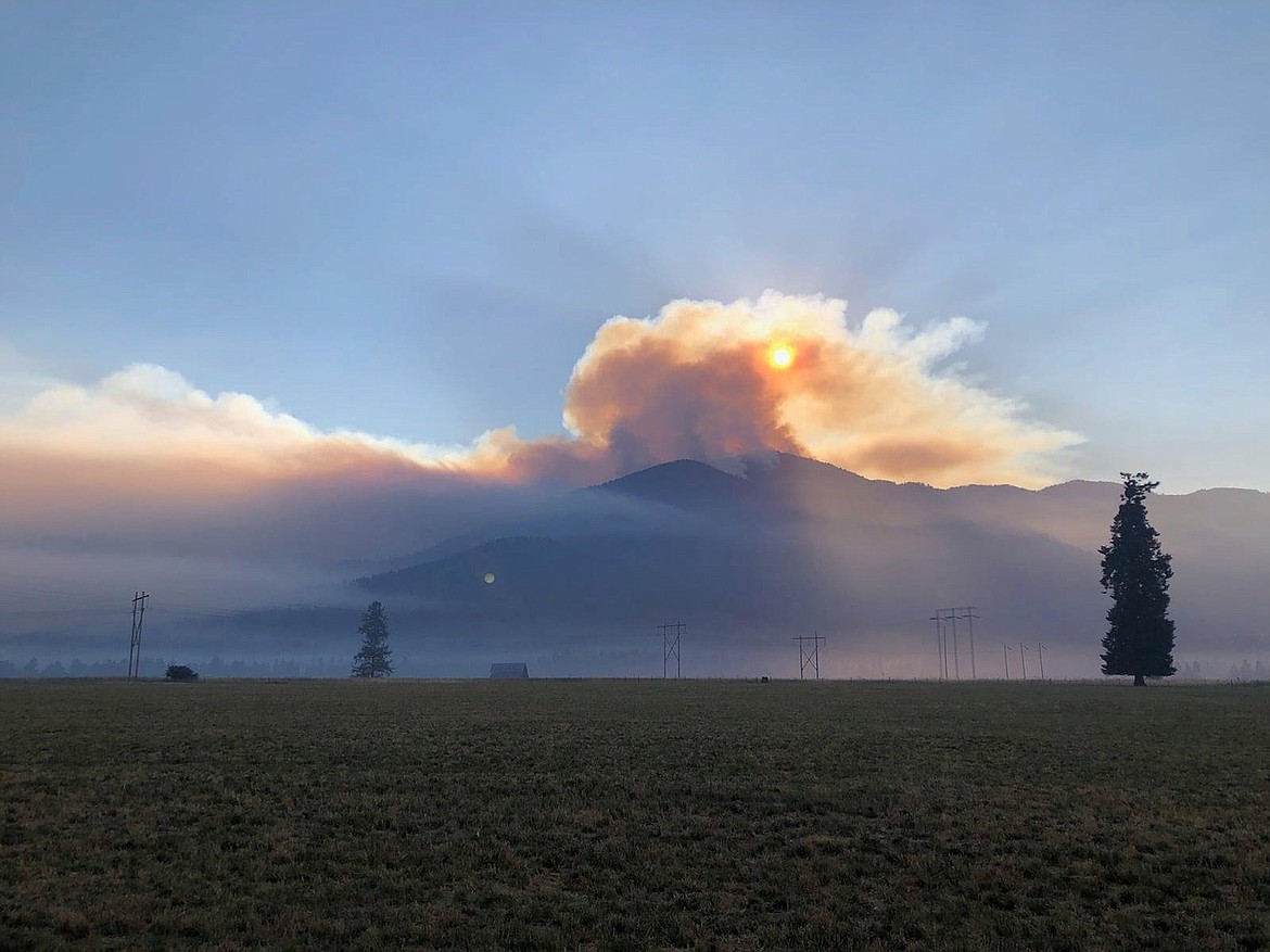
The Thorne Creek Fire burns near Thompson Falls on Tuesday, July 27, 2021. (Courtesy photo)
Wildfire activity has worsened significantly in recent days across Sanders and Lincoln counties, where a lack of resources and dangerous fire weather have contributed to the rapid spread of several large fires.
In Lincoln County, the South Yaak Fire is of particular concern to fire officials after it expanded nearly 1,400 acres Tuesday afternoon. At last report, the fire was at 3,382 acres and was 20% contained.
The fire is burning roughly 4 miles northwest of Troy and moving quickly through timbered, steep terrain. The fire was first reported on July 13 as a small blaze on the south slope of Yaak Mountain, but it quickly grew despite "heavy initial attacks" by firefighting personnel, which included support from helicopters and air tankers.
"The fire presents a challenge due to steep terrain, difficult access and critically dry vegetation," a status report noted Wednesday morning. "It is likely to burn until significant moisture covers the area."
The Lincoln County Sheriff's Office ordered mandatory evacuations for all residents on East Side Road and Kilbrennan Lake Road earlier this week. For the safety of firefighters and the public, the Kootenai National Forest also closed areas including O'Brien Creek Road, the North Fork O'Brien Creek and the Kilbrennan Lake campground.
Also in Lincoln County, the Burnt Creek Fire had spread to just over 3,000 acres by Wednesday morning, up from roughly 2,700 acres on Monday. The blaze, located about 9 miles southwest of Troy in the Burnt Peak area of the Keeler Creek drainage, was 31% contained.
Similar to the South Yaak Fire, the Burnt Creek Fire is burning in timbered and steep terrain. It is moving east and also backing down the north side of Burnt Peak, where, according to InciWeb, "vegetation is thick and terrain is difficult, making it unsafe for firefighters to work directly against the edge of the fire perimeter."
Active burning, short crown runs, isolated torching and short-range spotting are all occurring in the area, and fire crews are working to dig backup containment lines along Iron Creek and the ridge of Ground Mountain. Existing containment lines are on the southern edge of the fire, bordering the Keeler Rattle Road, the eastern edge and a portion of the northern side.
Some residences in the North Fork Keeler Creek have been placed on pre-evacuation notice, meaning all residents should be ready to leave at a moment's notice. The Kootenai National Forest also closed North Fork Keeler Creek, Keeler Rattle Creek and Lime Butte roads.
Earlier this month, the Great Basin Type 2 Incident Management Team took command over the South Yaak and Burnt Peak fires, both of which were believed to be started by lightning. Fire camps are located adjacent to Montana 56, south of the junction with U.S. 2, and north of Troy at the base of Yaak Mountain.
IN NEIGHBORING Sanders County, crews continue to fight the Thorne Creek Fire in the West Lolo Complex. More than 150 personnel are battling the blaze, which grew to 10,357 acres on Tuesday, up from about 5,600 acres on Monday.
The fire was 0% contained and, according to a Wednesday update, limited firefighting resources were exacerbating the problem. Officials say that's because there are currently 38 Type 1 and Type 2 teams on fire assignments across the country.
"Our resource requests are taken into consideration, along with the current fire situation, threats to life and property, and requests from other teams," the update said. "Thus, we may or may not have resources assigned that have been requested if there is a greater need elsewhere."
The fire is located about 5 miles northeast of Thompson Falls and began during a thunderstorm that swept over the region on July 7, igniting several fires across the Lolo National Forest.
Primary concerns over the next few days include "gusty and erratic winds," along with additional lightning activity, and temperatures that are expected to climb into the upper 90s in the coming days, with Friday and Saturday expected to be the hottest days.
The fire is deemed a "long-term event" due to its location in steep, rocky terrain with heavy downed trees that have made it difficult to access the area with heavy equipment and crews.
The Northern Rockies Team 1 has been in command of the fire since July 9. Air resources, smokejumpers, ground crews, engines and heavy equipment have all been used to suppress the fire, which is being managed under a "full suppression strategy."
A Type 1 interagency hotshot crew was expected to arrive Wednesday to assist with direct fire attack where possible. There are also three helicopters assigned, as well as two engine air tankers.
Approximately 206 residences are now under evacuation orders.
Full evacuation orders have been in place for residents from Cougar Creek south to the intersection of Blue Slide Road and River View Lake, those on the east side of Blue Slide Road in Graves North and South, and on the east side of the powerlines in Harlow. The Sanders County Sheriff's Office also ordered a new evacuation on Wednesday for those on the northeast side of the power lines in Ashley. That area was previously on pre-evacuation warning, but has now been ordered to evacuate.
Pre-evacuation orders are in place for residences from Cougar Creek south to the intersection of Blue Slide Road and River View Lane, and on the west side of Blue Slide Rock in Graves North and South.
STATEWIDE, THERE were 19 large fires burning in Montana on Monday. The state remains in a Preparedness Level 5.
Gov. Greg Gianforte was briefed earlier this week by fire managers with the state Department of Natural Resources and Conservation. A readout of that briefing said the Northern Rockies are the No. 1 priority region in the nation, and there have been over 600 wildfire starts in Montana in July alone.
A Gianforte spokesperson said in an email Wednesday that "the governor and fire management professionals stressed the importance of firefighter safety when responding to fire across the landscape."
The largest fire in the area is the Rovertain Draw Fire, at 89% containment, and the "top priority fire" is the Divide Complex Fire at 15% containment.
The state entered the fiscal year with the Fire Suppression Fund at its statutory maximum of roughly $105 million. Officials estimate that nearly $13 million from the fund have been spent fighting fires since the start of the state's current fiscal year.