Torrents of rain, miles of misery: 1964
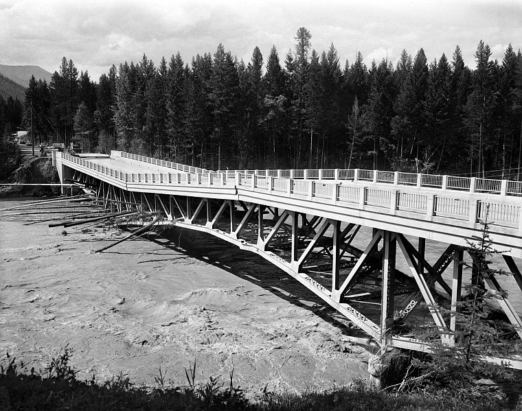
Debris carried in the flood of 1964 buckled the bridge over the Middle Fork at West Glacier, cutting off access to Glacier National Park.

Much of Evergreen was left under water in June 1964 when the Flathead River, swollen by torrential rains and melting snow, unleashed a monster flood.

When torrential rains poured on top of a heavy mountain snowpack
on June 8-9, 1964, it caused, by some measures, one of the most
powerful flash floods in the United States during the 20th
century.
Editor’s note: This story first was published in 2004, the 40th anniversary of the disastrous 1964 flood. It is being re-run because of the current flood potential.
When torrential rains poured on top of a heavy mountain snowpack on June 8-9, 1964, it caused, by some measures, one of the most powerful flash floods in the United States during the 20th century.
Water poured down both sides of the Continental Divide, tearing out roadways and rail lines and ripping away bridges. Three dams failed. Another was over-topped.
At least 28 people died and more than 2,200 homes and buildings were damaged or destroyed in seven counties and a dozen communities in Montana.
Nothing remotely like it had happened before, ever since white settlers first moved into the Flathead in the mid-1800s.
There had been prior floods, of course. Just 10 years earlier, peak flows along the main stem of the Flathead River topped 69,000 cubic feet per second — more than double the average flow during spring runoff and 50 percent higher than the flood stage flow of 47,000 cfs.
A 100-year flood — one of five that hit the Flathead during the preceding 50 years — took place on May 23, 1948. The flow at Columbia Falls peaked at 102,000 cfs, with a crest of 19.5 feet, 5.5 feet above flood stage.
However, the biggest flood in anyone’s living memory was in 1894, when the Flathead River roared through the valley at a monstrous 142,000 cfs, more than eight feet above flood stage. Old-timers said that event “backed water up from Flathead Lake almost to Kalispell.”
Still, no one was prepared for what happened in ’64.
John Dalimata, whose family farmed 800 acres in the Nyack Valley along the Middle Fork, said there was plenty of snow in the mountains that year plus cool spring weather that delayed any runoff.
“The ground was completely saturated,” Dalimata recalled. “We had a snow gauge up on the ridge above the farm. Old Rude Voss [Dalimata’s father-in-law] used to say that when the snow was gone from that ridge, we didn’t have to worry about flooding anymore. There was a lot of snow up there that spring.”
As of May 1, gauges across Northwest Montana were registering snow depths as much as 75 percent above average, with above-average water content.
Four days later, after storms dumped up to 13 inches of snow across the western half of the state, it already was the second-snowiest May on record, with more snow in the forecast. At least two new record lows were set during the month, and it wasn’t until just before Memorial Day weekend that the high temperatures broke 70 degrees.
On May 7, National Weather Service climatologist Richard Dightman issued the following caution: “We aren’t in trouble unless we get a sudden warming and the snowpack melts all at once. However, we don’t look for that to happen — very rarely does snowmelt by itself cause flooding. But if we get rain on top of it ... then we’re in trouble.”
The warning received little attention.
It started raining Sunday afternoon.
It wasn’t too bad down in the valley — a half-inch or so out at the airport.
But in the mountains it was a deluge: Essex got 11 inches in 30 hours; Marias Pass got 15.5 inches by Monday night.
Climatologists later determined that three storm systems had collided over the northern Rockies. Storms from the east and northeast combined with moisture-laden clouds from the south to produce a 37-hour torrent of rain — warm rain that cut through the deep, wet snowpack like a hot iron.
Quiet streams turned into boiling cauldrons. On Bear Creek, just west of the Continental Divide, the water scoured slopes down to bedrock, stripping them clear of trees, picking up massive boulders and tearing away part of the highway.
By Monday morning, June 8, Glacier National Park Ranger Bob Frauson and his wife, Ann, were evacuating their home in St. Mary on the park’s east side.
“We had to stay at the old 1913 ranger station,” Ann recalled. “About 50 of us were there. The whole valley was flooded. Divide Creek was a roaring river with big trees and rocks coming down. Bob and Ray Smith stayed on the main bridge into the park all day, pushing logs away.”
At 5:25 a.m., just east of Essex, the Middle Fork washed out a 200-foot section of the Great Northern railroad line. It took out the U.S. 2 bridge shortly thereafter, cutting off all ground transportation across the Divide.
Then it bore down on Nyack.
“The thing I remember is the noise, this great roar,” said Dalimata, who was 22 at the time. “It was terrifying.”
Dalimata’s home is about 30 miles west of the Divide and a half-mile south of the river. It’s also south of the highway and the railroad tracks, which split the valley east to west.
“We have 200 acres of hay meadow north of the tracks,” he said. “The week before, we’d moved our cattle over there, including about 100 yearling calves. We weren’t much worried about flooding. We’d had floods before, in ’48 and ’54, but they hadn’t done much damage. In an emergency, we just moved the cattle across the tracks to a Forest Service meadow we leased.”
But this time there was no warning, no indication of an impending disaster.
“The first I knew about it was when a big gush of water came out of the creek behind our house,” Dalimata said. “I jumped on a Cat [bulldozer] and started working in the creek, trying to keep it out of the wood pile. Then I dropped that and helped my dad try to get the cattle out. But we didn’t even come close. The water came up too fast.”
They drove into the meadow and started shaking pails of feed pellets — a sound that normally brought the cattle running.
“We tried to get them to follow us, but their instincts were to go upstream,” he said. “They ignored us. We followed, and that was almost our undoing. We barely made it out. I’m still not sure why we didn’t get carried away.”
As they did elsewhere in the Flathead, the Great Northern tracks acted as a dike, holding back most of the flood water.
“We ended up south of the tracks, by the state highway shed,” Dalimata recalled. “Dad and I sat there listening to the noise. There were cattle bawling, elk barking. Everything going down river. The force of the water was so great it would just snap trees off that were two or three feet in diameter. There were a bunch of log jams. When a big one broke upstream, a wall of water six feet high came down.
“My dad crawled up on a diesel tank by the highway shed and looked out over the tracks. That was probably hardest on him — he could see all those cattle and trees going down. All we could do was hear them.”
They lost 142 head, including the yearlings.
East of the Divide, the destruction was even greater.
Communities from Cut Bank to Great Falls experienced flood damage. Dams failed at Lower Two Medicine Lake and East Glacier. West of Dupuyer, Swift Dam failed as well, sending a 30-foot wall of water racing down Birch Creek. At least 28 people drowned.
West of Great Falls, there were reports that Gibson Dam had failed. A Forest Service pilot sent to investigate discovered a three-foot wall of water coming over the top of the dam — 66,000 cubic feet per second, according to the Bureau of Reclamation.
But the dam held.
Back in the Nyack area, a Fish and Game pilot barely had time to land on the highway and evacuate a handful of people, including Dalimata’s wife, Ruth, and his mother-in-law.
“As Ruth was flying out, she could see the railroad tunnel just west of here,” Dalimata said. “There was a full stream of water squirting out of it like a garden hose.”
People in West Glacier and Columbia Falls were unprepared for what was coming. Radio reports advised them that the river would crest at 15.5 feet — 1.5 feet above flood stage, but 4 feet less than the ’48 flood, which did little damage.
“We drove up to West Glacier on Monday morning and there were people standing out on the bridge watching the river,” recalled Katherine Lundstrom, whose husband, Darvin, was the Columbia Falls police chief at the time.
“Darvin’s mother and I and our daughter walked out there and could feel the whole thing shaking,” she said. “Darvin ran out and told us to get off, because he thought the bridge was going to go. After we came home, he changed clothes and left and I didn’t see him again for two days.”
Darvin and scores of other volunteers and professionals across the valley pitched in to help families evacuate. When the water got too high, they drove boats through the churning river to rescue people from rooftops and other high ground.
And the ground had to be much higher than anyone ever expected: The Flathead River level at Columbia Falls hit 15.5 feet at 4 p.m. By 8 p.m., it was at 18 feet and climbing a foot per hour.
The river finally crested Tuesday morning at 26.5 feet. Peak flows were an unheard-of 176,000 cubic feet per second.
By comparison, the Flathead is currently flowing at around 17,000 cfs; the river gauge is under 8 feet.
The flood waters spared little in the vicinity of the river.
More than 20 miles of U.S. 2 were damaged or destroyed, along with six miles of Great Northern track. A section of Blankenship Bridge collapsed Monday night and the bridge at West Glacier buckled. The eastern half of the Old Red Bridge in Columbia Falls also washed away, together with three homes; another 50 homes south and east of town were flooded.
“The water kept rising until it reached the bottom of ‘Dead’ on the Dead End sign on south Nucleus Avenue,” according to the Hungry Horse News.
Mel Ruder of the Hungry Horse News later won the Pulitzer Prize for his one-man, nonstop coverage of the 1964 flood.
Flathead County Commissioner Clifford Haines flew over the flood and described it in an interview: “It’s a solid river, three to four miles wide in many places. Many houses in the northern end of the valley aren’t just under water. They’re gone, completely washed away.”
Thousands of animals and whole forests washed away, too, clogging the river and Flathead Lake.
The final damage toll from the 1964 flood was estimated at $63 million — about $438 million in today’s dollars — including $28.4 million ($197 million in today’s dollars) in Flathead County.
The cleanup efforts took weeks. Great Northern hired 750 people and worked them 12 hours a day, seven days a week, to get its line across Marias Pass back in operation by June 29.
Glacier Park’s Going-to-the-Sun Road, which washed out in several places, didn’t open across Logan Pass until June 30.
The Dalimata hay meadow was a jumble of downed trees and debris piles. Ten miles of fence had been swept away. Two or three feet of silt had piled up in some places, and in other places there were the remains of the terrified cattle that had tried to swim upstream.
“The county sent a crew out here to bury them,” Dalimata recalled. “But they didn’t have much equipment and weren’t able to do much. Then the grizzlies took over. I don’t know how many bears were out here digging them up.
“With the cattle gone, we didn’t have any farm income that year. We took a half-million board-feet of downed timber off our place. That’s what we lived on.”
If there was a bright side to the disaster, he said, it was the people. They started pulling together all across the valley. Those who lived in areas unaffected by the flood opened their homes to evacuees. Hundreds of others volunteered their time and effort during rescue efforts and the subsequent cleanup.
“We had several families here that wound up staying on our lumber mill yard,” Dalimata said. “The women would cook for everyone. We ate pretty good. Neighbors took care of each other.
“That’s one of my best memories of the flood. There’s blessings in everything, if you just look.”