Prescribed burns planned around Northwest Montana
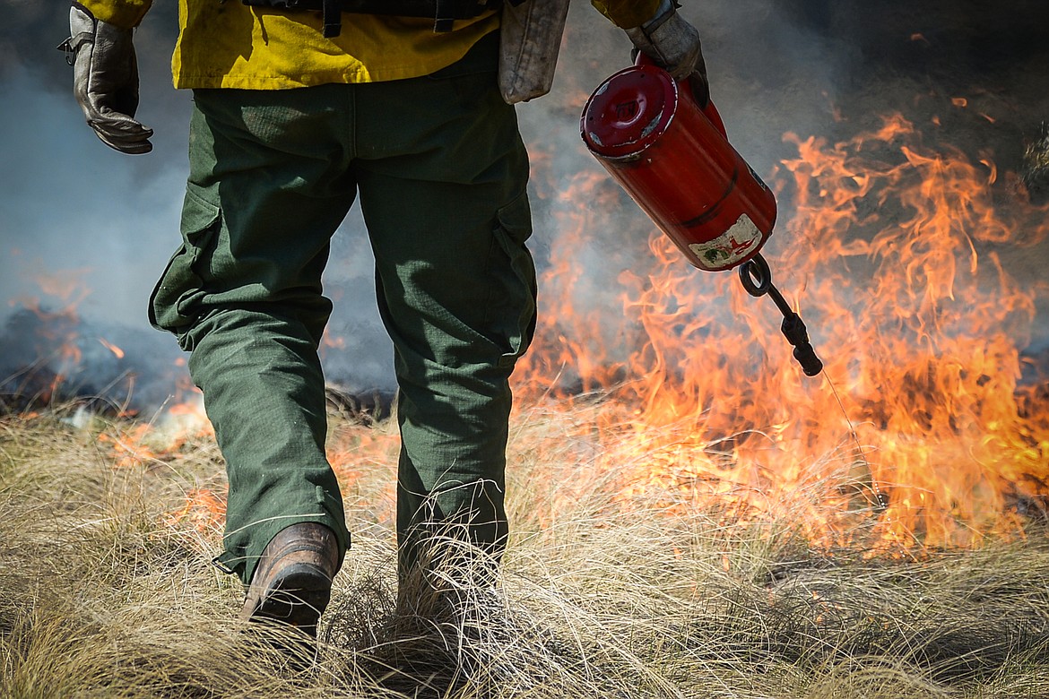
Nick Aschenwald, with the Montana DNRC, uses a drip torch to ignite bunch grass during a prescribed burn at Lone Pine State Park in Kalispell on Thursday, April 7, 2022. Held in conjunction with Montana Fish, Wildlife & Parks, the prescribed fire is aimed at benefiting the park's grassland habitat, including native plants and the wildlife species that frequent the area.(Casey Kreider/Daily Inter Lake)
The Flathead National Forest is planning to conduct fall prescribed fire projects when weather, fuel conditions, and air quality become favorable. Smoke will be visible from various places in the Flathead Valley depending on the location of the burn units and weather conditions.
Each project follows a prescribed fire burn plan. The prescribed fire projects are located and designed to be controlled to reduce the potential for adverse effects, or to escape as a wildland fire. These projects will follow Montana air quality standards and coordinated with Montana State Department of Environmental Quality to reduce the impacts of smoke to our neighbors, cooperators, and surrounding communities.
The project areas include:
Swan Lake Ranger District
Lindy Ridge Prescribed Burn - The objective of the prescribed fire is to treat 1,104 acres in and adjacent to the Mission Mountains Wilderness to reduce crown fire potential, decrease flame lengths and decrease spotting distance and, therefore, increase the probability that a natural ignition would stay within the wilderness boundary and fire could play its natural role on the landscape. More information will be forthcoming as the window of opportunity approaches.
How Now Timber Sale – This project includes broadcast burning in timber harvest units located on Sixmile Mountain, North of Swan Lake, MT. These treatments will use prescribed fire for fuels reduction, and vegetation regeneration.
Louie Timber Sale - This project includes broadcast burning in timber harvest units located within the Truman Creek drainage near Blacktail Mountain south of Kila, MT and west of Lakeside, MT. These treatments will use prescribed fire for fuels reduction, vegetation regeneration, and wildlife habitat improvement.
Swan Valley Bottom Maintenance Burning – This project includes maintenance broadcast burning in previously treated timber harvest units located within the Swan Valley. Specific locations include the Lion Creek Drainage, and Meadow Creek area. These treatments will use prescribed fire for fuels reduction, large ungulate winter range improvement, and improve forest health.
Tally Lake Ranger District
Whitefish Municipal Watershed – Several of the 5 units available ranging in size from 36-268 acres will prescribed burn natural fuels to reduce likelihood of crown fire, reduce stand density, improve mule deer and elk habitat and prepare areas for planting of White Bark pine. Units will be selected based on conditions at the time of ignition. Aerial ignition will utilize a helicopter. The burn will be highly visible from Whitefish and the greater Flathead Valley. More information will be forthcoming as the window of opportunity approaches.
Burnt Grouse 2.0 – Prescribed fire will burn 220 acres of natural fuels to reduce likelihood of high intensity fire and improve mule deer and elk habitat. Rocky Mountain Elk Foundation provided partial funding to help implement this project. The same area was previously burned fall of 2014. This second entry is designed to mimic fire history in the area by consuming dead and down lodgepole pine that was killed by the initial prescribed fire. The burn will be highly visible from the Olney and Good Creek areas.
Ashley Mountain - Prescribed fire will burn between 200 and 484 acres of natural fuels to reduce likelihood of crown fire, reduce stand density, and improve mule deer and elk habitat. The prescribed fire will also help protect our Ashley Mountain communication site from future fire. The burn will be highly visible from the Ashley Lake area.
Hungry Horse District
Red Whale Fuels Reduction— Approximately 750 acres will be targeted for prescribed burning this fall in Moose creek and Moran creek. This project location is in the North Fork of the Flathead about 4 miles northwest of Polebridge. Depending on weather this burn is planned for mid to late September to early October. The purpose of this project is to help restore a more historical fire regime to the ecosystem, improve wildlife habitat and reduce hazardous fuels to reduce wildfire risk and aid in potential future fire suppression efforts and improve wildlife habitat.
Belton Rx— This prescribed fire project targets 5 units totaling 916 acres. The project is designed to restore fire to the ecosystem and remove dead and down fuels while reducing conifer encroachment in openings to improve wildlife habitat. The units are located west of, and adjacent to, the northernmost portion of the Great Bear Wilderness near West Glacier.
Middle Fork Fuels Rx—This burn targets approximately 622 acres in 4 units. The prescribed fire treatments are designed to target the shrub-dominated areas with the objective of reducing conifer encroachment, rejuvenating wildlife browse, creating a diverse mosaic of vegetation conditions and across the landscape, and reducing fuel accumulations.
Betty Baptiste Rx—This project consists of approximately 352 acres in 3 units of high elevation prescribed fire near Baptiste lookout. The prescribed fire treatments are designed to mimic the effects of a wildfire by diversifying stand density and structure.
Royal Tiger 86—The objective of this prescribed fire unit is to reduce the downed fuel loading, to minimize wildfire hazard and to prepare the 16-acre site for planting.
Units with hand piles, machine piles or landing piles on HHGV districts include.
Hungry Lion Timber Sale (Abbot Basin, Royal Tiger) This project will treat 3,418 acres including harvest, prescribed fire and fuels reduction near Coram, Martin City and along the Eastside reservoir road (FS road 38). Landing piles and hand piles near Martin city, Coram and Emery Bay will be treated.
Crystal Cedar Fuels Reduction project. 50 acres of hand piles north of Columbia Falls on North Parker Road will be targeted. Several landing piles in the Cedar Flats area and in Crystal Creek will be burned.
Betty Baptiste Timber Sale. Landing piles and machine piles created in harvested units will be targeted to burn. Up to 918 acres of commercially harvested units will be treated during this project.
Hungry Horse Administrative site—This fuel reduction project targets 5 acres of hand piles adjacent to the HHGV ranger station.
North Fork Road PCT—5 acres of hand piles along the North Fork Road near Camas creek bridge.
ASCC Lion Lake Road—50 acres of machine piles along Lion Lake Road near Martin City.
Spotted Bear Ranger District
The units listed below around the Spotted Bear Ranger Station are being prescribed burned to reduce fuel loading, maintain and increase winter range forage and reintroduce fire into the ecosystem. Most units are a mix of grassy openings, shrub fields and timber patches. The objective is to reduce conifer encroachment while retaining key thermal cover timber patches.
Aerial Ignition - Spotted Bear River Unit E – 350 acres
Hand Ignition – Spotted Bear River Units 44, 45, 46, 71A and G – 140 acres total.