UM library makes historic aerial photos available online

Volunteer John Pierce compares original images to Google Earth using a light table to identify the coordinates for the centerpoint of each historical image. (Photo courtesy UM News Service)

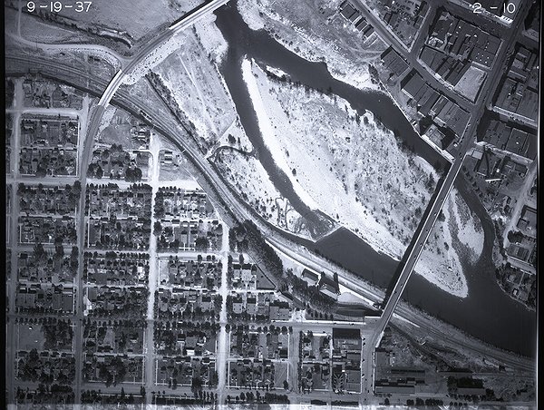
This 1937 image of Missoula shows an island in the Clark Fork River that today is Caras Park. (Photo courtesy UM News Service)
MISSOULA – Some of the state’s earliest known aerial photography now is available online courtesy of the University of Montana Mansfield Library.
The images are part of an extensive collection of aerial photography taken by the U.S. Forest Service and held in the library’s Archives and Special Collections department.
“The Forest Service collection we received has tens of thousands of aerial images dating from the 1930s to the 1970s,” said Professor Donna McCrea, the head of archives. “We are focusing on the imagery from the 1930s. So far we’ve created an online index map that indicates the latitude and longitude of about 35,000 images, and we’ve made about 3,500 images available online.”
Information about the collection, with links to the index map and scanned images, is online at umt.edu/library/asc/aerial/.
McCrea said the photographs are of land in the U.S. Forest Service Northern Region, which includes a significant amount of western Montana and northern Idaho. While the Forest Service originally used the photographs to assist with creating maps and conducting timber surveys, today they are used for a variety of purposes, including environmental studies, land-use planning and historic preservation.
She said the format of the images – 9-by-9-inch negatives on reels of film that contain 200 to 600 images each – has made providing access to them challenging. The library had to custom build a platform to safely hold the film reels as the images were being scanned.
“Initially, we didn’t receive any sort of index or inventory to the images, so we really didn’t know what we had” McCrea said. “We owe an enormous debt of gratitude to John Pierce, who volunteered his time over several years to identify the locations of the images. This project would not be possible without him.”
She said the project received a significant boost in 2022 with a $10,000 grant from the Foundation for Montana History, which funded a part-time project manager with Geographic Information System experience.
“We’ve been able to hire some really terrific UM students with GIS training in the past who helped us set up this project,” McCrea said. “The grant-funded project manager, Elizabeth Singh-Search, finalized our workflows and streamlined the online project map. I’m really pleased with the outcome and I can’t wait to see how these images get used now that they are more discoverable.”
UM geography graduate student Carver Butterfield recently used a selection of the Missoula-area photographs for his master's thesis project focusing on the impact of urbanization on Pattee Creek.
“These high-resolution images offered a vital baseline for what the creek looked like before urbanization,” Butterfield said. “This insight was foundational to my assessment of urbanization's impact on the creek. Looking back at history through aerial imagery not only enriches our understanding of the past, but it also guides us towards a more informed and sustainable future.”
The original images were sent from the Region 1 headquarters in Missoula to the National Archives in Washington, D.C., in the 1980s. UM Archives and Special Collections holds duplicate images that were gifted to the library in the 1990s. McCrea said the Forest Service does not have plans to digitize the originals, so the library took on the project.
“This new online collection of aerial photography adds to our many rich multidisciplinary library resources, with cultural and historical significance for western Montana as a place,” said UM Dean of Libraries Barry Brown. “It underscores the Mansfield Library’s mission to provide our campus and community members opportunities to understand the past, analyze the present and prepare for the future.”
McCrea said the Forest Service also took aerial photographs of the region in the 1920s, but the original nitrate film disintegrated before it could be sent to the National Archives for duplication. So the existing collection starts in the ’30s.
“Because prints were often made from the original negatives, I hope I’ll someday get a call from someone who has those Montana aerial images from the 1920s,” she said.
 This 1937 image of Missoula shows an island in the Clark Fork River that today is Caras Park. (Photo courtesy UM News Service)